The Nesebar Isthmus: the Link Between the Old and New Town
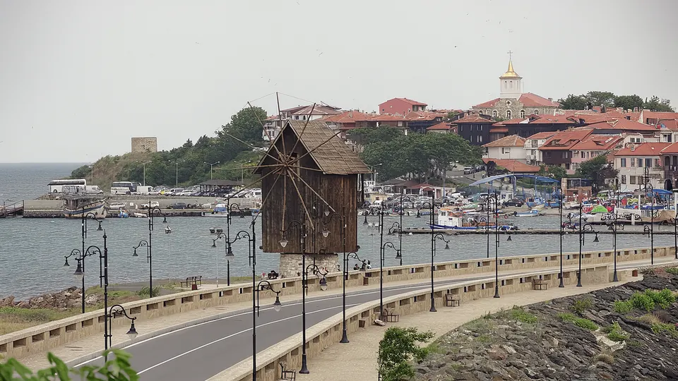
Old Nesebar stands on a rocky peninsula 850 m long and 350 m wide, joined to the mainland by a narrow isthmus (according to the Ancient Nessebar Museum and Nesebar Municipality). Today the isthmus is the main way into the Old Town. Here you will find the windmill – one of the symbols of the town – the harbours on either side and the fortress gate through which you enter ancient Mesambria.
The isthmus and World Heritage
The statement of Outstanding Universal Value of the Ancient City of Nessebar (criterion iv) speaks of "the outstanding natural configuration of the rocky peninsular, linked with the continent by a long narrow stretch of land". Nature and architecture are seen here as a single whole. The isthmus itself lies within the boundaries of the property: under the World Heritage Committee's 2008 decision, the boundaries take in the whole peninsula together with the isthmus. As early as 1981, Ordinance No. 8 on the architectural and historical reserves of Sozopol and Nesebar included in the reserve "the whole peninsula with the contact zone of 'the isthmus' linking the old and new parts of the town" (our translation). Council of Ministers Decree No. 174 of 1991 also includes the isthmus: according to the annexes to the Vision (2026), the reserve under it covers the whole peninsula with the isthmus, including the reclaimed land on the north shore, while the 2018 UNESCO mission cites it as covering the peninsula, the isthmus and a roughly triangular area on the mainland at its base.
How the isthmus has changed
Today's isthmus does not look as it once did. The Vision for the Ancient City of Nessebar (2026) notes that it has kept its role as the link between mainland, peninsula and sea, but after it was widened and reinforced it no longer matches the description "a narrow isthmus, almost invisible from afar" (our translation) in the 1982 nomination file. A comparative analysis by the National Institute for Immovable Cultural Heritage (NIICH), quoted by the joint World Heritage Centre/ICOMOS mission of 2023, states that the coastal reinforcement has altered the northern and south-eastern shores as well as the isthmus, which has become slightly wider. According to the Cultural Heritage Strategy of Nesebar Municipality, the coastal protection works began even before the World Heritage inscription and have enlarged the edges of the peninsula. The annexes to the Vision list the low parts of the isthmus among the areas at risk of potential flooding.
The windmill
The best-known landmark on the isthmus is the wooden windmill. It stands on the widened part of the isthmus, on the site of a Revival-period mill built on a quadrangular medieval tower. The present mill was rebuilt in 1968 from surviving archive documents (annex to the Vision, 2026). The municipal tourist guide gives a different history: the mill survived from Ottoman times, collapsed in 1929 and was put up again after 1944. A conservation and restoration project has been carried out (the documents give 2021 and 2022) – with municipal funds according to the annexes to the Vision, and with support from the Ministry of Culture according to the Cultural Heritage Strategy. Since 2023 the mill has been used as an exhibition space. Its first exhibition, "The Riches of the Ancient Necropolis of Mesambria", showed more than 100 objects from the 5th century BC to the 4th century AD.
The windmill is one of the sites of the Ancient Nessebar Museum: according to the 2026 price list (read on 28 October 2026) a ticket costs €2.56 for adults and €1.53 for children. It is one of three surviving windmills in Nesebar – the others are on the north shore next to the Basilica of the Holy Virgin Eleusa and in the mainland part of the town. There is more in our article on the windmills of Nesebar.
The harbours on either side
On the north-west side, just north of the isthmus, is the Severna Buna fishing port (report of the UNESCO/ICOMOS advisory mission, 2017). It was upgraded in 2022 after a heritage impact assessment approved by the World Heritage Centre. According to the Cultural Heritage Strategy, it has berths for up to 121 small vessels and a fish market for the fresh catch. On the south side, between the isthmus and the passenger terminal with the Sea Station, is the private yacht harbour Marina Nessebar. There is more about them and about the ancient harbours in our article on the harbours of Old Nesebar.
The gate and the fortress walls
At the end of the isthmus you enter the Old Town through the western gate. According to the museum, this is the best-preserved section of the Early Byzantine fortress wall of the mid-5th century. The walls of that period were built in opus mixtum – alternating bands of stone and brick – while at the gate the wall is faced with large, rectangular dressed stone blocks. The gate is flanked by two rectangular towers, with semicircular and round towers placed symmetrically on either side. The entrance was closed by two gates – a portcullis and a double-leaf door. The museum relates that when Khan Krum took the town in 812, after a 14-day siege, the fortress wall was destroyed; it was rebuilt in brick at the end of the 9th century.
Part of the fortifications continues under water. North-east of the isthmus, by the Argirova Buna jetty, the Centre for Underwater Archaeology is investigating the so-called diateichisma – a wall at right angles to the northern fortification line that blocked the way along the shore. It starts on land and continues under water. Three phases have been identified: a wall of large blocks, probably from the Late Classical or Hellenistic period (5th–4th century BC), a wall in opus mixtum from the 5th–6th century AD, and a barrier of piled-up huge stones, probably from the late Middle Ages or the Ottoman period. In the 2023 excavations, traces of a large fire were found on the outer side of the Early Byzantine wall. Bulgaria's state of conservation report to the World Heritage Centre tentatively links them to Krum's capture of the town in 812.
Beyond the isthmus
The newer part of the town begins on the mainland opposite the isthmus. According to the 2023 mission report, this spot offers a unique view of the peninsula, and the area on the mainland directly opposite the isthmus was once known as "The Dunes". This is where the necropolis of the ancient town lies – according to "Values and Attributes", the area was used for burials right up to the Ottoman period. Read more in our article on the New Town of Nesebar.
Practical information
- On foot: you can walk across the isthmus; this is also where a walk round the churches of the Old Town begins – for example to St John the Baptist and St Spas.
- By car: according to Bulgaria's state of conservation report to the World Heritage Centre, under the traffic schemes adopted by the Municipal Council for the 2023 and 2024 summer seasons only cars with a permit could enter the Old Town from 1 April; there were two checkpoints with automatic barriers – on Kraybrezhna Street next to the North Large car park and at the gate – and the speed limit on the peninsula was 20 km/h. Tourist coaches stopped for the new part of town at the Windmill car park. Check the current rules with Nesebar Municipality.
Sources
- Ancient Nessebar Museum, history of the town (Bulgarian)
- Ancient Nessebar Museum, fortress walls and towers (Bulgarian)
- Ancient Nessebar Museum, the windmills (English)
- Ancient Nessebar Museum, 2026 ticket prices
- UNESCO World Heritage Centre, Ancient City of Nessebar
- "Values and Attributes of the Cultural Heritage of the Ancient City of Nessebar", 2026 (PDF in Bulgarian, Nesebar Municipality)
- Shared Vision for the Ancient City of Nessebar (2026–2045), draft of 28 January 2026 (PDF in Bulgarian, Nesebar Municipality)
- Annexes to the Shared Vision for the Ancient City of Nessebar (2026–2045), 27 January 2026 (PDF in Bulgarian, Nesebar Municipality)
- Cultural Heritage Strategy of Nesebar Municipality 2023–2032 (PDF in Bulgarian)
- Nesebar Municipality, tourist guide (PDF in Bulgarian)
- Report of the UNESCO/ICOMOS advisory mission, 2017 (PDF)
- Report of the joint World Heritage Centre/ICOMOS mission, 2018 (PDF)
- Report of the joint World Heritage Centre/ICOMOS mission, January 2023 (PDF)
- Bulgaria's state of conservation report, 2023–2024 (PDF)
Checked on 28 October 2026. Car access rules and prices change, so check them before you travel.
Get local stories & deals
One email a month with the best Black Sea stories and seasonal deals. No spam.