The Harbours of Old Nesebar: History and the Ports Today
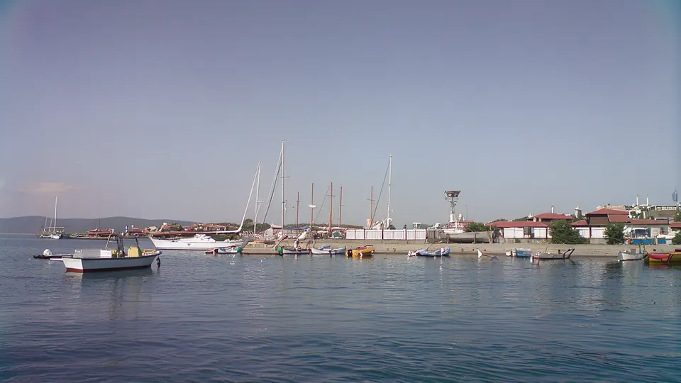
The sea has shaped life in Nesebar since the earliest times. According to the Ancient Nessebar Museum, Mesambria had two convenient harbours – a northern and a southern one – where remains of the equipment of ancient ships are still being found. Part of the ancient town and its harbour works now lie under water, and several working harbours still surround the peninsula today. Here is what the official sources say about the harbours of Old Nesebar, from the Bronze Age to the present.
The harbours in antiquity
- The Bronze Age. Bulgaria's 2023–2024 state of conservation report to the World Heritage Centre cites a study by K. Porozhanov (journal "Arheologia", issue 1, 1989): in the second half of the 2nd millennium BC two harbour zones were in use around the peninsula. One lay north of the peninsula and is attested by 23 stone anchors found there; the other was on the southern, sheltered side.
- The Greek colony. According to the museum, the first Greek settlers, Dorians by origin, arrived at the end of the 6th century BC. The description of the property on the UNESCO website gives the beginning of the 6th century BC. The town struck its own coins as early as the first half of the 5th century BC and traded with the cities of the Black Sea, the Aegean and the Mediterranean.
- Where the main harbours were. The document "Values and Attributes of the Cultural Heritage of the Ancient City of Nessebar" (2026) states that the main harbours were on the southern and south-eastern side of the peninsula, sheltered from the north and north-east winds. On the north side there was a temporary anchorage for loading and unloading and for shelter in strong winds. Above the so-called Northern Harbour, on a terrace, the foundations of a temple of Zeus Hyperdexios of the 5th–4th century BC have been found (Cultural Heritage Strategy of Nesebar Municipality 2023–2032).
- More than one harbour. We know from the Roman poet Ovid that Mesambria had more than one harbour ("Values and Attributes").
The sunken town
According to "Values and Attributes", at least a third of the ancient town is now under water, because of the rise in sea level, tectonic movements, abrasion and erosion. Fortress walls, breakwaters and architectural remains have been found about 170 m from today's shore and down to 6 m depth. According to the Cultural Heritage Strategy, the first underwater surveys took place in 1960–1984, when 15 expeditions were carried out under the direction of Lyuba Ognenova. In 2015 the research was resumed by the Centre for Underwater Archaeology, and since 2017 it has been carried out every year.
What has been found so far (according to "Values and Attributes", the 2023 ICOMOS evaluation and Bulgaria's 2023–2024 state of conservation report to the World Heritage Centre):
- The breakwaters. On the south-eastern side of the peninsula two monumental breakwaters of piled stones have been identified. "Values and Attributes" dates them to the Early Byzantine period (5th–6th century), the 2023 ICOMOS evaluation to Late Antiquity or later. One is straight and about 90 m long; the other is L-shaped and measures 45 × 45 m. "Values and Attributes" describes them as the largest ancient architectural structures found so far in the Black Sea.
- Harbour deposits. Accumulations of artefacts – mainly pottery and anchors – have been found in the waters of the ancient harbours.
- A new date. According to Bulgaria's 2023–2024 report, in 2023 radiocarbon dating of timbers from the base of a wall in the sea south-east of the peninsula showed that the so-called "Thracian wall" was not built by the Thracians before the founding of the Greek colony, but by the Dorian settlers soon after they arrived, in the Late Classical period.
- The old sea level. The base of an Early Byzantine wall investigated in 2024 in the small bay south of the South Buna jetty is an indication that in the 5th–6th century the sea level was about 2.5 m lower than today (same report).
- The bay of Ravda. An underwater survey in one of the bays of Ravda in 2024 found a large amount of ancient pottery – evidence that the bay was used as a harbour. Three fragments of Late Bronze Age pottery were also found.
In 2023 the World Heritage Committee extended the property with three underwater areas – north-west, south-east and south of the peninsula, 7.61 hectares in all. The southern area contains submerged remains that ICOMOS describes as an ancient street along today's shoreline; "Values and Attributes" is more cautious and suggests the structure of large flat stones may be a street paving, a platform or the base of a fortress wall. In October 2026 Nesebar Municipality announced that, together with the Centre for Underwater Archaeology, it is preparing underwater tourist routes and "dry diving" with virtual-reality glasses at the tourist information centre in Old Nesebar.
The Middle Ages and the Ottoman period
The museum writes that in the 12th and 13th centuries Nesebar developed lively trade with the Mediterranean and Adriatic lands and the principalities north of the Danube. In 1201–1263, when the town was part of the Bulgarian state, it traded with Constantinople, Venice, Genoa, Pisa, Ancona, Dubrovnik and other towns. Under Ottoman rule the port of Nesebar remained a main import and export centre on the Black Sea coast. According to the source cited in the report to UNESCO, Mesemvria appears in all medieval portolans and is regularly marked in red on 14th–15th-century nautical charts. According to "Values and Attributes" (2026), the Church of Christ Pantocrator now houses the museum's exhibition "Nesebar and the Bay in Old Maps (4th–19th century)" – eighteen maps from different branches of European cartography.
Seafaring has also left its mark in the churches: according to Bulgaria's 2023–2024 report, St Spas, St Theodore, St Stephen and St John Aliturgetos preserve more than 300 single or group graffiti of ships. Read more in our articles on St Spas and St Theodore.
The harbours today
According to the Cultural Heritage Strategy, there are six harbours in the municipality with different owners and uses. Around Old Nesebar they are:
- Port Nesebar with the Sea Station. The passenger terminal for public transport is in the south-western part of the peninsula. The Sea Station was built in the 1960s and lies within the buffer zone of the World Heritage site. The terminal is part of the Port of Burgas for public transport and has been under a 35-year concession since 8 September 2014. Large ships have not called here for years: 4 ships came in 2016, 1 in 2017 (with 102 passengers), 1 in 2019, and no cruise or passenger ship in 2020–2022. Today the port is used mainly by fishing vessels, fishing boats, yachts and small tourist boats.
- Marina Nessebar. A private yacht harbour in the south-western part of Old Nesebar, between the passenger terminal and the isthmus.
- Severna Buna fishing port. On the north-west side, just north of the isthmus. It was upgraded in 2022 after a heritage impact assessment approved by the World Heritage Centre. It has berths for up to 121 small vessels and a fish market for the fresh catch.
- Severno Pristanishte (North Harbour) Nesebar. A yacht harbour used mainly by small tourist boats for trips round the bay and for transfers to Sunny Beach and Elenite. The municipality owns and operates it, and the work is done by the municipal enterprise "Port Infrastructure Nesebar", set up in 2022.
The UNESCO/ICOMOS missions of 2018 and 2023 recommend moving the passenger terminal and Marina Nessebar off the peninsula in the long term. In the 2023–2024 report the Bulgarian side quotes the opinion of the Maritime Administration Directorate in Burgas, which does not accept this recommendation, because the terminal already existed in the same form when the site was inscribed in 1983.
What to see around the harbour
- The old lighthouse tower. According to the municipal tourist guide, the lighthouse was first lit on 25 July 1932. After the breakwater was built in 1954, a four-sided metal structure 7.5 m high with electric optics was put up.
- The street named after Angelo Roncalli. It leads to the Sea Station. In 2014 a memorial plaque to Angelo Roncalli – later Pope John XXIII – was unveiled here, with an inscription of gratitude for his good deeds for the town in 1925–1934.
- The Old Town Hall. The building dates from 1929 and was restored in 2014. There is a view of the harbour from its terrace.
- The amphitheatre. It is next to the harbour, close to the Church of St John Aliturgetos; festivals and performances are held on its stage.
- St Nicholas' Day. On 6 December the faithful carry the icon of St Nicholas through the town to the harbour, where the fishermen receive their ship's icon. By old tradition, boats go out to sea and blessed wreaths are thrown into the water (Cultural Heritage Strategy).
How to get there
From the gate at the end of the isthmus, head down to the southern shore of the peninsula: on the Ancient Nessebar Museum map this is where the southern fortress wall and the churches of St Stephen and St John Aliturgetos are. Boats to Sunny Beach leave from the South Port and from the North Port (municipal guide). For the way into the Old Town see our article on the isthmus, and for the modern part of the town, on the New Town.
Sources
- Ancient Nessebar Museum, history of the town (Bulgarian)
- Ancient Nessebar Museum, temporary exhibitions (Bulgarian)
- Ancient Nessebar Museum, map of the sights
- UNESCO World Heritage Centre, Ancient City of Nessebar
- ICOMOS evaluation of the underwater extension of the property, 2023 (PDF)
- Report of the UNESCO/ICOMOS advisory mission, 2017 (PDF)
- Report of the joint World Heritage Centre/ICOMOS mission, January 2023 (PDF)
- Bulgaria's state of conservation report, 2023–2024 (PDF)
- "Values and Attributes of the Cultural Heritage of the Ancient City of Nessebar", 2026 (PDF in Bulgarian, Nesebar Municipality)
- Cultural Heritage Strategy of Nesebar Municipality 2023–2032 (PDF in Bulgarian)
- Nesebar Municipality, tourist guide (PDF in English)
- Nesebar Municipality, underwater tourist routes (22 October 2026, Bulgarian)
Checked on 28 October 2026. Boat timetables and conditions in the harbours change, so check them locally.
Get local stories & deals
One email a month with the best Black Sea stories and seasonal deals. No spam.