Beyond the Cobblestones: A Day Trip to the Wild Beauty of Cape Emine
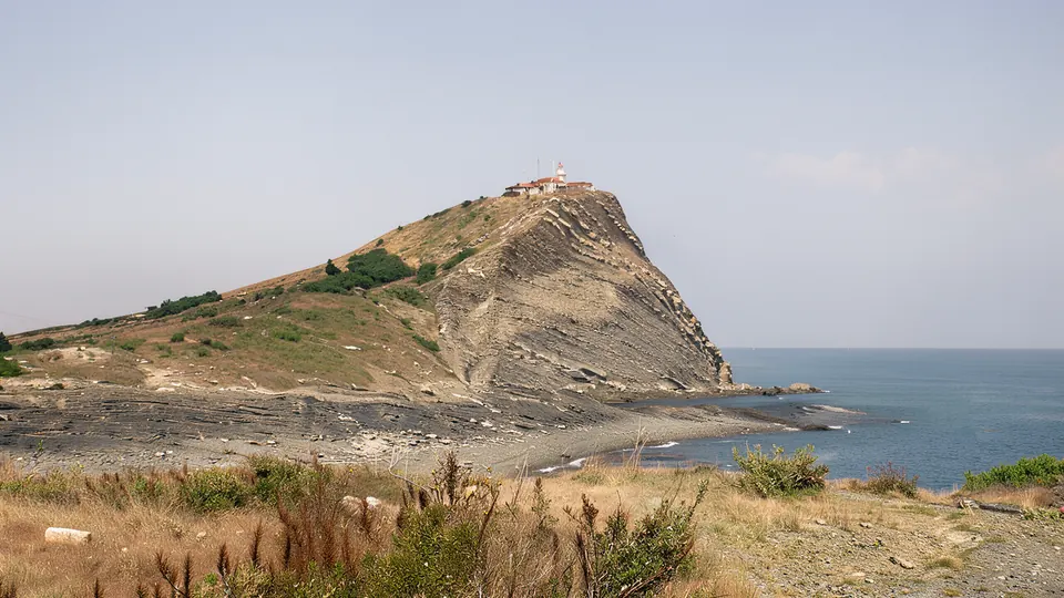
While Nessebar enchants with its ancient churches and cobbled streets, a short journey north reveals a dramatically different face of the Bulgarian Black Sea coast. Cape Emine, the easternmost point of the Balkan Mountains, offers a rugged and untamed escape for adventurous travelers. Here cliffs plunge roughly 60 meters into the churning sea, creating a panorama that feels worlds away from the bustling resort towns.
The contrast is half the point. In the morning you can be walking stones polished by millions of footsteps — if you are still planning your days, start with our complete guide to Nessebar Old Town — and by afternoon be standing on an edge where the only sounds are wind, gulls and waves on rock. No stalls, no music, no shaded cafe.
Where the mountain walks into the sea
Stara Planina crosses Bulgaria from west to east and ends right here, not with a summit but with a cliff above water. The range's ancient name, Haemus, gave the cape its name.
The geology is legible with the naked eye: layered sedimentary rock, tilted and split by fractures, eaten from below by the sea and crumbled from above by rain and wind. That is why the rim is not a straight line but a series of steps, landslip tongues and detached blocks grown over with grass — and why you should keep well back from it. The same rock, depth and current make this one of the best stretches of coast for diving and snorkeling near Nesebar.
Emona, Paleokastro and a lighthouse you cannot enter
Perched on the heights are the ruins of the medieval fortress of Emona, also known as Paleokastro, a strategic stronghold that once guarded these shores. What survives is mostly low walling and traces of towers following the natural relief; a moat of that fortress was uncovered during construction of the lighthouse. The nearby village of Emona, about 39 km from Nessebar and within Nessebar municipality, carries the same name, and legend calls it the birthplace of the Thracian king Rhesus, a hero mentioned in Homer's Iliad — a good story, but legend rather than documented fact.
Standing sentinel over the cape is the white lighthouse built in 1880, still guiding ships through these treacherous waters. One detail trips people up: it sits inside a restricted military zone and cannot be visited. There is no tour and no viewing platform. You see it from the paths and benches beside it, which is plenty for a photograph.
The end of the Kom–Emine trail
This is where Kom–Emine finishes: the Bulgarian section of European path E3, usually quoted as roughly 650 km, with route variants stretching it past 700 km. For a walker who set out from Kom in the far west, the cape is simply where the mountain runs out of land, and a short stroll along the ridge makes that logic obvious. For more coastal walking, see nature and hiking near the Black Sea.
A protected area, and what that means for you
Cape Emine is a designated protected natural landmark. The windswept landscape shelters rare coastal plants and the cliffs are a nesting ground for seabirds. In autumn the Via Pontica migration route passes overhead — see birdwatching near Nesebar along Via Pontica.
In practice: no fires, no driving off the track, take all rubbish back, stay on the paths in nesting season, and leave plants and fortress stones where they are.
The drive, honestly
A car is the practical option, since public transport here is limited, and the drive through rolling hills and quiet villages is scenic in itself — see renting a car in the Nesebar area. The final stretch is a rough unpaved track. Most people park where the asphalt ends and walk the last 2 km or so, about 20–30 minutes each way.
| Rough timing | What happens |
|---|---|
| 08:30 | leave Nessebar while it is cool |
| 09:30 | reach Emona village (about 39 km) |
| 09:45 | park where the paved road ends |
| 20–30 min | walk the final 2 km to the cape |
| 1–2 hours | ruins, views, lighthouse from the side |
| lunch | drive back and eat in Nessebar |
Practical information
- Getting there: about 39 km by road, last section unpaved; park and walk roughly 2 km.
- What to bring: at least 1.5 l of water per person, sturdy shoes, sun protection, a windproof layer, snacks and a rubbish bag. There are no shops, no cafes and no shade at the cape, and strong wind is normal even in summer.
- When to go: late May, June and September are most comfortable; in July and August set out early, because midday here is fully exposed.
- Cost and time: no entrance fee, so fuel and lunch only; half a day realistically, a full day with a beach stop. See also the best day trips from Nesebar, and the interactive map of Nesebar for how the peninsula sits against the coast road north.
Frequently asked questions
Can I go inside the Cape Emine lighthouse?
No. The 1880 lighthouse lies within a restricted military zone and is closed to visitors. You can see and photograph it from the footpaths and benches beside it, and that is as close as anyone gets.
Can I reach the cape in an ordinary car?
You can drive to Emona village on normal road, but the final section is a rough unpaved track and is not advisable in a low car. Park where the pavement ends and walk the last 2 km, which takes 20–30 minutes.
Is it suitable for children?
Yes, for children used to walking, provided you keep a firm distance from the cliff edge — there are no railings and the wind can be strong. Bring water and hats, and walk in the morning rather than at midday.
Get local stories & deals
One email a month with the best Black Sea stories and seasonal deals. No spam.